Tornados
by Peter J. Robinson
University of North Carolina at Chapel Hill, Department of Geography
Reprinted with permission from The North Carolina Atlas Revisited. Managing editor: Alfred W. Stuart.
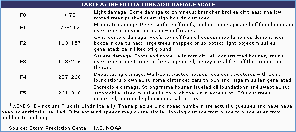 North Carolina's tornados are not able to compete with those of the central USA in frequency or intensity, Rarely exceeding F2 on the Fujita scale (shown in Table A). But sometimes they are features of weather which have major impacts. Most tornados are associated with isolated thunderstorms, and they tend to occur as small, relatively weak and isolated events. So their impact is usually minimal and local, with the amount of damage or injury caused depending greatly on exactly where the event occurs. So, in general, there are between 10 and 20 tornado days per year, most days having one or perhaps two tornados (Table 6). At irregular intervals there are more severe outbreaks, with several tornados spawned by a single weather system, and with more widespread impacts. Hurricane Floyd, for example, created 20 tornados along the coast on September 15, 1999.
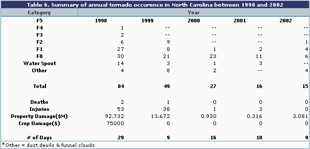 The two major outbreaks of the last few years occurred during 1998. Of the 29 days with tornados that year, 20 of them had a single event. None of these had an intensity greater than F1, most did less than $25,000 in damage and only one produced any injuries. On the other hand, 10 storms occurred on March 20 when a large, well-organized line of thunderstorms drifted northeastward across the northern Piedmont. Even then, only one, an F3 storm, did serious damage as it traveled 12 miles from southwest of Mayodan to just northwest of Eden in Rockingham County. Approximately 600 residences and numerous businesses were destroyed or damaged, including one industrial building where damage was estimated at $25M. Two deaths and numerous injuries were also caused. The second and larger outbreak occurred a couple of months later, this time associated with a series of thunderstorms generated in eastern Tennessee. They brought hail, high winds and rain on a swath from Madison County through Forsyth County, with at least 20 individual tornadoes involved. The severest was an F4 in rural Caldwell county, which caused two injuries but did relatively little damage. In contrast, an F3 storm went through a housing subdivision near Clemmons, Forsyth County, destroying several houses and damaging hundreds more, giving property damage totaling over $50M and at least five injuries.
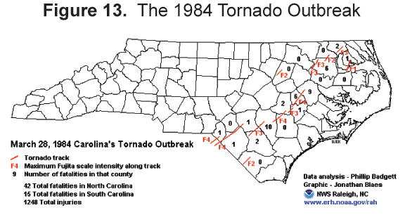
No part of the state is immune from tornados, although the main events of 1998 affected only parts of the mountains and the Piedmont. However, the Coastal Plain, as Figure 2.18 in The North Carolina Atlas indicates, is the major tornado location. That region was certainly the location of the largest single outbreak on record. And this was an outbreak worthy of the mid-west (Figure 13). The system started in South Carolina, entered the state over Union County around 5 p.m. on the afternoon of March 28, 1984. At 9:20 p.m. that night, it died away as it moved over Chowan and Perquimans Counties into Virginia. In North Carolina, 25 tornados between them did over $325 million dollars worth of damage, killed 40 citizens and injured 400 others. In terms of human life, this was one of the greatest natural disasters the state has ever known.
References and additional resources:
NC LIVE resources on tornados in NC.
Orr, Douglas Milton, and Alfred W. Stuart. 2000. The North Carolina atlas: portrait for a new century. Chapel Hill: University of North Carolina Press.
Resources on tornados in NC in libraries [via WorldCat]
Robinson, P. J. 2005. North Carolina weather & climate. Chapel Hill, NC: Published in association with the State Climate Office of North Carolina by the University of North Carolina Press.
State Climate Office of North Carolina.
State Library and State Archives Digital Collections.
1 January 2005 | Robinson, Peter J.