Volcanoes
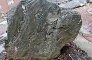
The geologic record suggests volcanic activity in what is now North Carolina primarily occurred in two phases of the middle Proterozoic era, between 850 and 500 million years ago, first while the ancient North American and Euro-African plates were moving apart, then while these same plates were colliding. During the first phase, 840 to 800 million years ago, eruptions occurred under the ancient Iapetus Sea and on land. Volcanic ash and lava flows deposited underwater and interbedded with layers of mud and sand are now part of the Ashe Formation stretching from Ashe and Watauga Counties in North Carolina into Franklin County, Va. The first eruptions on land occurred about 820 million years ago on the Piedmont Terrane, along the present North Carolina-Virginia border in the environs of Mount Rogers. These eruptions continued for at least 220 million years and deposited some 3,000 meters of volcanic and sedimentary rock.
The second phase of volcanic activity, beginning around 750 million years ago and lasting more than 300 million years, occurred along an arc of island volcanoes on the Avalon Terrane, a collision zone between the Iapetus Sea and the Theic-Rheic Ocean. Intense folding and metamorphism have destroyed most evidence of these eruptions, but the rocks created are present in the Carolina State Belt stretching southward through the midsection of the state. The eastern boundary of the belt is undetermined as it lies beneath the Coastal Plain, while the western boundary roughly passes near Greensboro, Thomasville, Lexington, Salisbury, Charlotte, and into South Carolina. Remnant volcanic necks and masses of igneous rock are evident in Orange and Chatham Counties, suggesting an early center of volcanic activity near Chapel Hill, dated at around 700 million years old, and near Hillsborough, dated at about 650 million years old.
Volcanic eruptions may have occurred during the middle Eocene epoch, about 47 million years ago, in the northern and western regions of the state, but erosion has removed all cones or other evidence of such activity. Also, volcanic ash deposits (bentonite) in the Castle Hayne Formation in the Coastal Plain are not believed to be native to the region, but possibly deposited by winds from a volcanic center in Virginia or from eruptions forming the island of Bermuda. There are no known active volcanoes in North Carolina today despite some geologic instability on the coast.
References:
Fred Beyer, North Carolina, the Years before Man: A Geologic History (1991).
Mary-Russell Roberson and Kevin G. Stewart, The Geologic Story of the Carolinas: A Field Guide (2006).
Additional Resources:
Geological Society of American, Bulletin of the Geological Society of America, volume 20.
Stewart, Kevin G., and Mary-Russell Roberson. 2007. Exploring the geology of the Carolinas: a field guide to favorite places from Chimney Rock to Charleston. Chapel Hill: University of North Carolina Press.
Image Credit:
Ashe formation. Image courtesy of the McKinney Geology Teaching Museum, Appalachian State University. Available from http://mckinneymuseum.appstate.edu/rock-garden/ashe-formation (accessed July 30, 2012).
1 January 2006 | DiNome, William G.
